ユーザ用ツール

サイト用ツール


20180714_opendatathon_in_sakai

文書の過去の版を表示しています。


厄払い!オープンデータソン in さかいの記録

歩いたところ

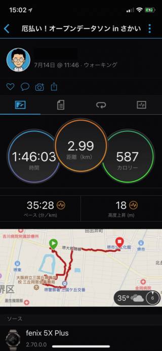
概ね3Kmを,約1時間45分で周りました.当日は班分けはしませんでした.

operating instructions

Various functions are available as part of the map.

mouse/touch operation
  • moving by grabbing the map with a mouse-click you can move the map around
  • overview map using the + button in the bottom right of the map you can expand an overview map
  • zooming in and out using the + and - buttons in the top left of the map you can obtain more or less detail in the map
  • switching themes or maps clicking on the ≡ icon on the right-hand side of the map you can view and select available maps and themes
  • retrieving information the map may contain elements that contain more information, by clicking these a popup will show this information
  • fullscreen display using the ✈ button the map can be maximized to fullscreen display, use the ✕ button to return to page display.
keyboard operation

Keyboard operation becomes available after activating the map using the tab key (the map will show a focus indicator ring).

  • moving using the arrow keys you can move the map
  • overview map using the + button in the bottom right of the map you can expand an overview map
  • zooming in and out using the + and - buttons in the top left of the map or by using the + and - keys you can obtain more or less detail in the map
  • switching themes or maps clicking on the ≡ icon on the right-hand side of the map you can view and select available maps and themes
  • retrieving information the map may contain elements that contain more information, using the i key you can activate a cursor that may be moved using the arrow keys, pressing the enter will execute an information retrieval. press the i or the escape key to return to navigation mode
  • fullscreen display using the ✈ button the map can be maximized to fullscreen display, use the ✕ button to return to page display.

It's possible that some of the functions or buttons describe above have been disabled by the page author or the administrator


Points of Interest
id symbol latitude longitude description
GPX file GPX track GPX track: logger 2747391

イベント全体

イベント全体は, Wikipedia のアウトリーチに記載されています.このページでは,それ以外について少し触れます.

暑い!

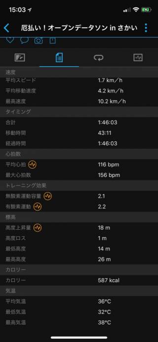
とにかく暑いオープンデータソンでした. 私は最近 Garmin の GPS 付きスマートウォッチを購入し,Garmin Connect で日々の活動を見始めています. このイベント当日はこんな感じでした.

平均気温36度,最高気温は38度だったようです(あくまで Garmin の結果です)

私は目下ダイエット中なのですが,このイベントの消費カロリーは 587kcal だったようです.

あまりに暑いので

参加された皆さんは, ここの自動販売機(OSM地図)で飲み物を購入されていました. 水分補給必須です.私も 500ml の水筒を持っていきましたが,すぐに無くなり,この自販機で飲み物を買いました.

OSM作図

OSM作図は,初心者と熟練者で分かれて作図をしました.初心者はiDの使い方を講師から聞きながら,主に方違神社を作図していましたが,すぐに慣れたようで,他のところも作図されていました.

iD はブラウザさえあれば編集できるので手軽ですが,タグのコピー&ペーストができないようで,類似の地物をタグ入れするときは少し手間がかかります.

それでもほぼ時間内にOSM作図が終わり,最後の成果発表で,各自どこを作図されたか発表されました.

20180714_opendatathon_in_sakai.1531728917.txt.gz · 最終更新: 2018-07-16 17:15 by tosihisa@netfort.gr.jp